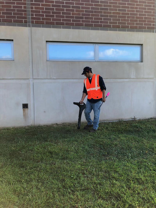
A utility strike occurs every minute in the United States. One of the most cited reasons for strikes is insufficient locating practices. EM locators are the most common tool to reduce the likelihood of damages.
The complexity of underground utility networks is continually increasing, and obtaining precise information on the location of buried utilities has never been more important. The protection of buried assets during excavation work demands accurate mapping and surveying of existing utilities.
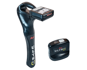
This system is optimised specifically for utility tracing
|
Technical Data |
Standard | Advanced |
|---|---|
|
Dimension |
691 x 325 x 122 mm |
|
Weight (including batteries) |
2.2 kg (4.8 lb) |
PERFORMANCE |
|
|
Frequency range |
50 Hz - 200 kHz |
|
Sensitivity |
33 kHz (1 μA at 1 m) |
|
Dynamic range |
117 dB |
|
Depth, max |
6 m (20 ft) |
|
Locate accuracy |
±5% depth |
|
Dynamic overload protection |
30 dB (automatic) |
|
Depth accuracy |
In line - ±5% to 3 m (±5% to 10 ft) |
FEATURES |
|
|
Enabled frequencies |
512 Hz, 3.14 kHz, 8.192 kHz, |
|
Custom frequencies |
Up to 100 custom frequencies from 256 Hz - 83 kHz |
|
DE direction enabled |
Any frequency from 256 Hz - 10 kHz |
|
Fault-finding DE based |
263 Hz |
|
Cathodic protection frequencies |
100 Hz, 120 Hz |
|
Power frequencies |
50 Hz, 60 HZ, 100 Hz, 120 Hz, |
|
Language support |
17 user selectable |
|
Selectable auto shutdown |
5, 10, 20 or 30 minutes |
|
PC based configuration |
Software updates and configuration can be set by user |
|
High contrast graphical LCD |
✔ | ✔ |
|
Line direction compass with proportional L/R arrow guidance |
✔ | ✔ |
|
Offset depth |
| ✔ |
|
AIM |
| ✔ |
|
Receiver / transmitter communications |
| ✔ |
|
Bluetooth® connectivity |
| ✔ |
ENVIRONMENTAL |
|
|
Operating temperature |
-20 °C - 50 °C (-4 °F - 122 °F) |
|
Storage temperature |
-32 °C - 70 °C (-25 °F - 158 °F) |
|
Environmental protection |
IP65 |
|
BATTERY |
|
|
Batteries |
2 D-cell (LR20) |
|
Battery life (max) |
30 hrs continuous |
|
Technical Data |
5 Watt | 12 Watt | Advanced |
|---|---|
|
Dimension |
254 x 305 x 91 mm |
|
Weight (including batteries) |
3.4 kg (7.7 lb) |
PERFORMANCE |
|
|
Frequency range |
256 Hz - 200 kHz |
|
Output power |
5 Watt | 12 Watt | 12 Watt |
|
Current, max |
500 mA |
|
Voltage, max |
65V rms |
FEATURES |
|
|
Enabled frequencies |
512 Hz, 3.14 kHz, 8.192 kHz, |
|
Custom frequencies |
Up to 100 custom frequencies from 256 Hz - 83 kHz |
|
Language support |
17 user selectable |
|
Induction |
16 induction frequencies |
|
PC based configuration |
Software updates and configuration can be set by user |
|
Fault-finding DE based |
263 Hz |
|
Multimeter functions |
Watts, currents, ohms and volts |
|
High contrast graphical LCD |
✔ | ✔ | ✔ |
|
External 12V power connection |
| | ✔ |
|
Dual output |
| | ✔ |
|
Receiver / transmitter communications |
| | ✔ |
ENVIRONMENTAL |
|
|
Operating temperature |
-20 °C to 50 °C (-4 °F to 122 °F) |
|
Storage temperature |
-32 °C to 70 °C (-25 °F to 158 °F) |
|
Environmental protection |
IP65 |
BATTERY |
|
|
Batteries |
10 D-Cell (LR20) |
|
Battery life (max) |
100 hrs with alkaline |
Offset depth
Measures horizontal and vertical distance to the line
Ambient Interference Measurement (AIM)
Measures interference and recommends best frequency
Receiver / Transmitter communications
Remotely control transmitter frequency, power level and more
Bluetooth®
Wireless connectivity to GIS field PC, GNSS receiver
Dual output
Remotely select active output (must have optional dual output leads)
Induction frequencies
8.01 kHz, 8.192 kHz, 8.44 kHz, 9.82 kHz, 29.4 kHz, 32.8 kHz, 39 kHz, 44.6 kHz, 65.5 kHz, 78.1 kHz, 80.4 kHz, 82.5 kHz, 83.1 kHz, 89 kHz, 131 kHz, 200 kHz
Links